Identifying and finding a site to implement a food forest can take several weeks to months if not years. Agricultural land, especially near cities, has become a scare and expensive resource. Besides food production, land is increasingly used for energy production, housing development and as an investment. Furthermore, agricultural businesses usually operate with (and hence sell) hundreds of hectares rather than 1-2ha which would be sufficient for a food forest start-up. Small-scale farming plots can be more difficult to find.
Ideally, a set of suitability criteria exists to help select a site. The table below gives an overview on relevant site search criteria and definitions based on our site search in Lüneburg, Germany and Phoenix, Arizona. Criteria can include, amongst other, a minimum size, accessibility by a potential user community and stakeholder interest in comprehensive sustainability solutions. Comparing available sites against different criteria can help in the decision process and can guide later planning activities. E.g., the further away the site location is from the farmers’ home, the simpler the design should be (Björklund 2019).
Table 3: Selection criteria used for the site search in Lüneburg and Phoenix
| Site criteria | Definition |
| Size | A coherent area of min. 5.000 sqm (0,5ha) size to be economically feasible and provide forest-like ecosystem services |
| Distance to home | The distance between farm and residence of the forest farmer shows to highly effect management success. The closer, the better, e.g., walking or cycling distance. |
| Accessibility of user community and supporters | Proximity of potential user community for products and services, and supporters for volunteering (e.g., community center, school, hospital, kindergarten, environmental NGO, university, government, green/sustainability/social enterprise or food outlet and others using/marketing the use of local produce). |
| No restrictive regulations | Land use type should allow planting of a multi-strata agroforestry system. In Germany, this is possible on crop fields but not on pastures, in forests or nature reserves. In Arizona, flood protection areas prohibit planting of trees. Other regional or national regulations may apply. |
| Ownership | If land is leased: Is there opportunity for long-term partnership? What is the economic value of the site? Especially in cities, e.g., a high value could mean uncertainty about future whereas vacant, underutilized or marginal area (e.g., with slopes) could offer opportunity. |
| Level of contamination or pollution source | What is the history of the site? E.g., a former airport, miliary land or industrial sites can be highly polluted. This can also lead to legal restrictions in food production. Who is the immediate neighbor? E.g., a conventional farmer is likely to use herbicides, pesticides and chemical fertilizer. An autobahn is likely to bring high levels of air and soil pollution. |
| Accessibility to water | Are water access points available? Or can it be accessed through a well or surface water? Local water administration can provide more detailed information, e.g., the depth of ground water which influences costs for a well, or potential restrictions on daily quantities. |
| Existing vegetation | Nearby green infrastructure can enhance biodiversity of the site, e.g., green corridors, parks or forests. Existing vegetation may be included in the design and gives insights on soil conditions and what may (not) grow well. |
| Area with sustainability challenges | How pressing are sustainability challenges in the area (e.g., food desert, high microclimate, low food literacy, low income)? Marginalized communities often lack green infrastructure and healthy food; hence, a food forest brings them multiple benefits. This may support stronger collaborations and access to public resources. |
Search strategies for a site can include formal and informal ways. Networking and finding a site through existing relationships with local organizations and agencies or other personal contacts can provide for a trustful base. This is especially relevant when leasing a site which requires a good long-lasting relationship with the land owner. More on shared values for strong partnerships can be found in Chapter 9. More formal places for a site search include the real-estate market or assigning one or several real estate agents with a search. Other sources may be to contact institutional staff like the sustainability manager or land administrator of the local town or city, the church or like-minded associations or institutions with access to land.
Our search process in Phoenix included a set of GIS (Geographic Information System) maps jointly developed with a GIS project at Arizona State University. The maps showed potentially suitable public land about which we spoke with the sustainability manager of the City of Phoenix. However, a simple web search for likeminded projects in the region on “permaculture/organic/regenerative….farm/school/housing association…” and reaching out to personal contacts may be just as effective. We found both the site in Lüneburg and Phoenix through these more informal ways.
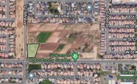
Map of the urban farm Spaces of Opportunity and the southwest parcel for the food forest (green)
| Spaces of Opportunities, Phoenix, Arizona | ||
| Project partners | Orchard Learning Centre, TigerMountain Foundation, Desert Botanical Garden, Roosevelt school district | |
| Activities | 1,8 ha cultivated by 9 farmers (2019; all farm land cultivated in 2022 by 18 farmers), on-site farmers market, CSA and community garden | |
| Size | 0,5ha parcel on a 7,6ha urban farm | |
| Distance | Around 18km to ASU Tempe | |
| Community access | Directly adjacent is a low-income, diverse neighborhood with several schools | |
| Regulations | No restrictive regulations for agroforestry | |
| Ownership | Owned by Roosevelt school district; land trust idea | |
| Contamination | No contamination, former agricultural land | |
| Water Access | Mostly flood irrigation through canal system | |
| Onsite infrastructure | Restrooms, parking lot, pop up market, high tunnel, refrigeration, performance stage | |
| Sustainability challenges | • Urban sprawl • Urban heat island • Lack of green space • Food deserts • Racial exclusion • Environmental degradation • Economic disparities | |
The next step is creating a database to compare all potentially suitable sites in your region along the selection criteria. This overview and systematic comparison can help in decision making. Personal contact helps to gain the relevant information and discuss the project idea. Once a site is selected, a collaboration agreement or Memorandum of Understanding with shared goals and a project timeline ideally is developed and signed. Although not legally binding, it firms and formalizes the commitment to collaborate and provides a shared understanding of the project outline and responsibilities.